
Since 1992
Print and digital marketing
PHOTO: The Rotary Club of Brunswick celebrates the installation of a plaque commemorating the location of the Skofield Shipyard in Harpswell. (Submitted photo)
BRUNSWICK — The Rotary Club of Brunswick on Dec. 28 installed a plaque and marker at the site of the former Skolfield Shipyard and Farm. The property, on Skolfield Drive in Harpswell, was the site of a prominent shipyard from 1799 until 1875.
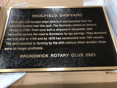
The plaque reads: “More than 100 wooden ships were built and launched from the shipyard located near this spot. The Skolfields settled as farmers nearby in 1739. Their sons built a shipyard in Harpswell, later relocating across the road to Brunswick for tax savings. They launched the first ship in 1799 and by 1875 had constructed over 100 vessels. The land reverted to farming by the 20th Century when wooden ships were no longer profitable.”
The property, owned by Erik C. Sol and Larkin B. Keyes, is in an area once called Merrucoonegan, which means “easy carry” or “drag your canoe across.” The narrow isthmus provided an alternative to the otherwise long and dangerous paddle around Harpswell Neck and the islands to get to the New Meadows and Kennebec rivers.
The shipyard built more than 100 vessel, ranging from James Badger at 890 tons in 1848 to the Sam Skolfield at 1590 tons in 1875, and just one clipper ship, Rising Sun. In 1870 when the government ruled that all vessels had to indicate the hail as the nearest customs district, the Skolfields placed Portland as the hail, but added “Built in Brunswick” on the ships.
The ships carried cotton, fish, wood, and apples to Europe and returned with wine, iron, and immigrants. They brought sugar from the West Indies and hides, jute, and tea from Asia. After the decline of wooden ships, the land returned to farming.
Rotary club then-president Richard Leighton in 1995 recommended a series of historical markers in the Brunswick/Harpswell area recognizing important sites that may not otherwise be noted. Initially, funding for this project was by a 25-cent donation by each Rotarian, resulting in a $2,500 initial program funding, as well as the profits from the 70th anniversary gathering in 1995.
There are now 17 local site of historical significance that have been identified and commemorated with a plaque through the efforts of the Brunswick Area Pride and Heritage Committee. The plagues are provided by the Rotary Club of Brunswick with assistance from The Pejepscot Historical Society, The Village Heritage Society, The Mid Coast Region Redevelopment Authority, and the Brunswick High School Alumni Association. For more information on the historic sites and plaques, visit brunswickmainerotary.org.
Historic plaques installed by the Rotary Club of Brunswick include:
1995, Town Farm Cemetery (circa 1831) Monument is inside a fenced burial field beside Brunswick Public Works Department at the end of Water Street, Brunswick.
2000, Mill Cove Tide Mill (circa 1830), Grist Mill Site; High Head Road on the crossing of Mill Cove, Harpswell.
2001, Brunswick Town Commons (circa 1719) 1000 acres of common usage space, SW corner, 2.5 miles South on Harpswell Road. Walk the trail into the Commons about 500 yards. Brunswick.
2001, Orr’s Island Public Library (circa 1905) about a mile before the Cribstone Bridge, Orr’s Island.
2001, Androscoggin Falls (circa 1600) Anniversary Park Overlook, lower level, just before the Brunswick-Topsham Frank J. Wood Bridge, Abenaki Indian land and waters, Brunswick.
2003, Site of Thomas Purchase log cabin (circa 1628) Brunswick’s first settler and trader, The Daniel Hotel, 10 Water St., Brunswick, at the base of the flagpole, Brunswick.
2004, Site of many water-powered mills (circa 1715) Androscoggin River ocean shipping origin, and first upper falls dam, (circa 1753), lower Main Street at the corner of Green Street, Topsham.
2005, Brunswick Mall (circa 1823) “Public walk for rest and recreation,” at the Mall Gazebo. Brunswick.
2008, Wharton Point (circa 1686) Named for settler Thomas Wharton, Brunswick terminus for commercial coastal vessels and early settlers, about 2 miles past Brunswick High School to the Head of Maquoit Bay, at the end of Maquoit Road known as 12-Rod Road, Brunswick.
2010, The Holbrook Wharf (circa 1853) Historic waterfront, three buildings, Cundy’s Harbor, East Harpswell, Sebascodegan Island. (Erected June 2011)
2012, Site of the Former Brunswick High School (circa 1937-1995) Harriet Beecher Stowe Elementary School inside the parking lot entrance off Spring Street, Brunswick.
2013, Site of The Brunswick Railroad Station (circa 1855) Brunswick Station Complex, Visitor Center exterior wall, central entranceway leading to the steps of the Amtrak Downeaster train platform, Brunswick.
2013, Site of the Curtis Memorial Library (circa 1883/1904) Brunswick’s public library, 23 Pleasant St., exterior wall to the right of the main entrance, adjacent to the Book Drop slot, Brunswick.
2014, Site of the First Brunswick High School (circa 1851-1915). 46 Federal St., formerly Hawthorne School, and now superintendent of schools district office, exterior wall, entranceway ramp, Brunswick.
2015, Site of the U. S. Naval Air Station Brunswick (circa 1628-1943) Brunswick Landing at the Orion P-3 aircraft interim Legacy Park on Fitch Avenue, just before the former Navy Chapel, now the Brunswick Naval Museum & Memorial Gardens, Brunswick.
2018, Senter’s Department Store/Senter Place (circa 1909) A “Specialties in Dry Goods” store now known as Senter Place, 114 Maine St., Brunswick.
2021, Skolfield Shipyard, Harpswell.


